History
Scott County
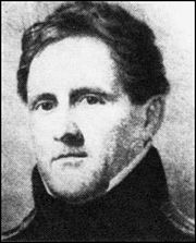 Scott County was organized on July, 5 1886, in honor of Major General Winfield Scott, United States Army, hero of the Mexican War. Scott served under every president from Jefferson to Lincoln, a total of fourteen administrations, and was an active-duty general for thirteen of them; a total of 47 years of service. Historians rank him highly both as a strategist and as a battlefield commander. Scott was born June 13, 1786, and died at age 79 on May 29, 1866.
The Dismal River Culture lived in the Beaver Creek area before history was written. Taos Indians escaped Spanish rule around 1664 and settled in what is now Lake Scott State Park. Picurie Indians lived here for a few years, around 1701. El Quartelejo is roughly translated as old barracks or distant quarters. About 1706 Juan Uribarri claimed the spring-fed valley, that protected El Quartelejo, for Spain, and called it San Luis Province. This is the only known pueblo in Kansas & is the farthest north & east known in America.
Battle of Punished Woman Creek, formerly known as Squaw's Den, is the site of the last battle between United States troops and Indians in Kansas. Chief Dull Knife and Little Wolf of the Northern Cheyenne, and their people, slipped away from the reservation in Oklahoma in 1878. On September 27, the band made a stand on Beaver Creek (Punished Woman Creek). A marker is placed above the pit where the women and children hid during the battle.
Early History...
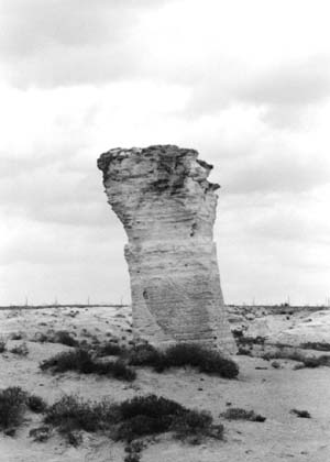 One of the most important archaeological relics of early life in Kansas is the ruins of an old pueblo north of Scott City in the Scott county state park. Scientists have agreed that these ruins are the long lost remnants of the pueblo El Quartelejo, which was established about 1702 by some adventurous Pueblo Indians from the town of Picuries in New Mexico. Originally it was a stone and adobe building of 32 by 50 feet, and was divided into seven rooms.
Probably this was the first walled house constructed within the present borders of Kansas. The ruins were visited in 1898 by Profs. S.J. Willston and H.T. Martin of the Kansas University, who derived many interesting facts and recovered numerous relics. In it were found stone, flint and bone implements, mealing stones, pots-herds, a quantity of charred corn and other things used and found in an Indian pueblo of the Rio grande, New Mexican type. There is no record or evidence that Spaniards or other white had anything to do with its construction or ever lived there, and it seems that the Pueblo Indian owners of El Quartelejo were soon persuaded by the Governor of New Mexico to return to their former home.
Probably this was the first walled house constructed within the present borders of Kansas. The ruins were visited in 1898 by Profs. S.J. Willston and H.T. Martin of the Kansas University, who derived many interesting facts and recovered numerous relics. In it were found stone, flint and bone implements, mealing stones, pots-herds, a quantity of charred corn and other things used and found in an Indian pueblo of the Rio grande, New Mexican type. There is no record or evidence that Spaniards or other white had anything to do with its construction or ever lived there, and it seems that the Pueblo Indian owners of El Quartelejo were soon persuaded by the Governor of New Mexico to return to their former home.
Scott county was created by an act of legislature in 1873, and named in honor of General Winfield Scott. For several years it had no population, and so needed no local form of government, but it was attached to Ford county for judicial purposes. Very soon after people began to settle there, a petition signed by the required number of citizens was presented to the board of county commissioners of Finney county requesting that Scott county be organized as a municipal township and attached to Finney county for judicial purposes. Scott county was organized as a township of Finney county, and Scott Center (the present Scott City) was designated as the place of transacting public business. A township election was held in Scott Center July 7,1885, and the following officers were electected: Trustee, Charley L. Waite; Treasurer, C.R. Swan; Clerk, M.H. Bailey; Road Overseer, W.E. McLain; Justice of Peace, S.W. Case and Joseph Hollister; Constable Ira J. WoIf.
In June, 1886, Charles Reed was appointed enumerator of Scott county by the governor, and after taking the census, it was found that it had the required number of inhabitants (1,500) to proceed with a county organization. Eugene McDaniel, A.H. Kilpatric, and M. Cunningham were appointed commissioners, and Charles Reed county clerk. The county was declared organized July 5, 1886, and that day the appointed commissioners and county clerk met in special session with Eugene Mcdaniel, chairman. An election was called to be held August 10, 1886, and at that time the following officers were elected: Charles Reed, County Clerk, W.R. Hadley, Treasurer; B.F. Griffith, Register of Deeds; S.T. Burgess, Clerk of the District Court; J.F. Daniels, Sherriff; Lulu Boling, County Superintendent; Dr. J.F. Bond, Coroner; Eugene McDaniel, Commision of 1st District; H.M. Connor, Commissioner of 2nd District; C. Garrett, Commissioner of 3rd District. The county seat was located at Scott Center by unanimous vote.
The county has an area of 720 square miles and 460,800 acres, with an elevation of 3,000 feet. Four-fifths of the county is smooth, and reaches away before the vision like the placid surface of a waveless sea. Here and there are fine reaches of billowy prairie, with long graceful slopes dipping gently into valleys; long reaches of low-laying bottom lands skirt the clear-winding streams, which are generally flanked by low hills and occasional picturesque bluffs. In the center of the county a few miles to the south of Scott City, is the famous White Woman basin, a tract of low, bottom land, 25,000 acres in extent. It is a black alluvial deposit of great depth. In this basin the White Woman suddenly sinks into the earth and takes its subterranean course along and beneath the basin where it is forever lost to sight. The annual overflow of the river, which has its source in the foothills of Colorado, floods the basin with its surplus waters which quickly sink again into the bed of the lost stream. It is claimed that so strong is the current of this subterranean river, at flood time, that the sound of its swift waters can be heard distinctly some distance from the mouth of several of these sink holes, and the listener is left to wonder when and where these wild waters shall again see the light of day.
Several stories have been told as to why this basin was called the White Woman, and perhaps all are wrong, but the following story is a favorite. The towns of Friend and Shallow Water lie close together in the basin of White Woman river and people living there say this is how the basin got its name. "The family settling at Shallow Water and the lone man who settled at Friend were neighbors for that day. And the daughter of Shallow Water meant to marry the bachelor of Friend. The level Navajo, twelve miles north to south and less than 100 miles east to west, was ordinarily a dry-bed stream, and the lovers were wont to meet midway between their homes. But when the snow melted and came down from the mountain ranges far to the west the stream became a raging torrent. On a lonely night the waters came down with a rush and the man was swept away in the swirling torrent. The girl's mind was weakened by her loss, and every night she walked along the basin, looking for her lover. The wraith is seen there now, it is said, and those who in an older day met the white-robed `something' presumed to be the spirit of the lady in search of her lover, christened it, `the Valley of the White Woman'."
The Beaver and the White Woman, both clear streams, with numerous spring brook tributaries reaching out in different directions, have always supplied pure water for the stockman. The county also embraces many fine flowing springs, and wells of both hard and soft water are easily obtained at fifteen to fifty feet depth for irrigation purposes. Quarries of building stones are found in certain sections of the county, including the white-, gray- and cream-colored magnesian Iimestones. Native timber was limited to small belts and groves along the streams.
Scott City is the county seat and chief town in the county. It was founded in September, 1885, by the Scott City Town Company, composed of Dr. Hall, F.A. Parsons, S.W. Case, Mrs. M.E. De Geer, Mrs. F.A. Parsons, Mrs. I.L. Eastman, W.E. McLain, Mrs. D.F. Hall and Messrs, Sangster and Swan, who filed their charter in that month and soon after laid out the town. They changed the name from Scott Center to Scott City at this time. There was never any county seat fight in Scott county, as Scott City was located in the geographical center of the county and from the very first held the key to the situation. The spirit of clique and discord and division that ruined many Western Kansas towns, never entered Scott county.
In 1886 the town had three weekly newspapers, four banks, a board of trade, two hotels and fifty other business concerns. The Masonic, Odd Fellows and Good Templers' lodges, and a post of the Grand Army of the Republic, the A.K.W.R. society and the Women's Christian Temperance Union had flourishing organizations. The ladies of the Woman's Christian Temperance Union erected a two-story building in 1886. The lower story was leased to the county for official and clerical uses, and the hall above was used for literary and social gatherings. They also provided a free library and reading room for the public. The officers of the W.C.T.U. were : Mrs. M.L. Parsons, president; Mrs. Mary E. Clark, secretary, and Mrs. I.L. Eastman, treasurer. The Methodist church was the first edifice of worship erected.
Scott City had many land and loan men in 1886. Dr. D.F. Hall laid out a 104-acre addition to the northeast division of the original townsite and sold many business and residence sites. Frank H. Miller became largely interested in both city and country property, and in 1886 established the Traders' Bank. Mr. Miller made a handsome fortune in handling Scott City property. The Scott City Real Estate Company with Frank A. Capps, president, and Charles Clark, secretary, opened a land and loan office. Thompson , McNabb & Landis, real estate and loan agents, did a large business. The Western Kansas Land and Loan Company was organized by James H. Camfill, but in 1887, sold his interests to Tom Kennedy of Harper, Kansas. The land department of the company was conducted by Messrs. S.L. Hughes and P.H. O'Gara. Smith, McLain & Company, land and loan agents and land attorneys, with W.O. Bourne as junior member of the firm. Mr. Bourne had a fine suburban claim. Morse & Perry, real estate and loan firm, began business in 1887. Kelley & Fitts also did a capital business in real estate and farm loans.
Johnson Brothers & Service, whose bank was founded in February, 1886, by Johnson Bros., was the pioneer banking house of the county and was a strong, well-organized concern. The Scott County Bank was incorporated in 1886 by Samuel M. Jarvis, R.R. Conklin, C.G. Larned, H.J. Hunt, F.A. Parsons and J.D. Jarvis, and opened its doors with a capital of $50,000. The Traders Bank was organized in 1886 by Frank N. Miller and friends, was shortly re-organized, the new incorporators being ex-Governor George W. Glick and S. B. Glazier, of Atchison, W.L.C. Beard, M.J. Keys and Frank H. Miller. The fourth bank was opened in 1887 under the firm name of McKnight & Nicholson.
Prominent among the professional men were Traverse Morse, attorney; Messrs. Hadley and Hubbell, the former attorney for the county, the latter county superintendent of schools. The medical profession was finely represented by Dr. J.F. Bond, who was the first doctor to settle in Scott county Dr. Ira W. Bouldin, and Dr. Arbuthnot, physician and druggist, whose partner in the drug business was Mr. Eggleston, a breeder of thoroughbred horses, and farmer.
Kansas: a cyclopedia
Scott County, in the western part of the state, is the third county east from Colorado, the fourth south of Nebraska, and the fourth from the southern boundary of the state. It is bounded on the north by Logan and Gove counties; on the east by Lane; on the south by Finney, and on the west by Wichita. It was created in 1873 and named for Winfield Scott, a hero in both the War of 1812 and the Mexican war, and commander-in-chief of army at the beginning of the Civil war in 1861. The boundaries were described as follows: "Commencing at the intersection of the east line of range 31 west with the 3d standard parallel; thence south along range line to its intersection with the 4th standard parallel; thence west along the 4th standard parallel to where it is intersected by the east line of range 35 west; thence north along range line to its intersection with the 3d standard parallel; thence east to the place of beginning."
The organization of the county was effected in 1886. In May Charles S. Reed was appointed to take the census. The returns were made on June 29 and showed a population of 2,675, of whom 701 were householders. The valuation of property was $364,063, of which amount $109,030 was real estate. Gov. Martin issued the proclamation the same day whereby he organized the county, named Scott City as the county seat, and appointed the following officers: County clerk, Charles S. Reed; commissioners, Marion Cunningham, A. H. Kilpatrick and Eugene McDaniels. The first election was held on Aug. 10 and resulted as follows: County clerk, Charles S. Reed; probate judge, Thomas Poulson; treasurer, W. R. Hadley; sheriff, B. F. Daniels; register of deeds, J. B. Johnson; attorney, C. C. Hadley; district clerk, S. T. Burgess; superintendent of public instruction, Miss Lulu Boling; surveyor, W. E. Daugherty; coroner, J. F. Bond; commissioners, H. M. Cranor, C. Garrett and Eugene McDaniels. Scott City had no opposition for county seat.
The first settlers came into the county in 1874. The first white women were Mrs. M. E. DeGreer and her daughter, Mrs. Ida Eastman, both widows. In 1893 Scott was among the counties which suffered from the fuel famine. The county commissioners visited Topeka to secure state aid, but were not successful. In 1884 the ruins of a pre-historic pueblo were discovered in Scott county about 12 miles north of Scott City. (See Archaeology.)
The county was divided into Michigan, Beaver, Scott, Valley, Keystone, Isbel and Lake townships in 1886, and no new townships have been organized. The postoffices are Grigsby, Manning, Modoc, Pence, Scott and Taft. The Missouri Pacific railroad enters in the northeast and crosses southwest to Scott, thence directly west into Wichita county. A branch of the Atchison, Topeka & Santa Fe from Great Bend enters in the east and crosses west to Scott where it terminates.
The general surface is an undulating prairie with a few sand hills. The principal stream is Ladder creek. It enters from the west, flows east about 9 miles, then north into Logan county, where it empties into the Smoky Hill river. White Woman creek enters in the southwest and flows east and northeast to the center, where it sinks beneath the surface in the midst of a large basin which is filled only in wet seasons. Magnesian limestone is in the north and southwest. Sandstone, gypsum and cement rock also exist in limited quantities.
Less than half of the land in the county is cultivated. The value of farm products in 1910 was $607,766. Wheat brought $106,043; corn, $64,534; oats, $44,949; barley, $34,577; broom-corn, $26,729; sorghum, $158,928; milo maize, $32,400; hay, $27,379; animals sold for slaughter, $24,836; poultry and eggs, $16,327. The value of live stock on hand was $768,013.
The population in 1890 was 1,262. During the next three or four years the population decreased somewhat on account of the hard times. In 1893 there were 300 families, only 75 of them having the means to live through the winter. In 1900 the population was 1,098; in 1910 it was 3,047. The assessed valuation of property in 1910 was $5,913,442. The average wealth per capita being $1,940.
Pages 655-656 from volume II of Kansas: a cyclopedia of state history, embracing events, institutions, industries, counties, cities, towns, prominent persons, etc. ... / with a supplementary volume devoted to selected personal history and reminiscence. Standard Pub. Co. Chicago: 1912. 3 v. in 4. : front., ill., ports.; 28 cm. Vols. I-II edited by Frank W. Blackmar. Transcribed July 2002 by Carolyn Ward.